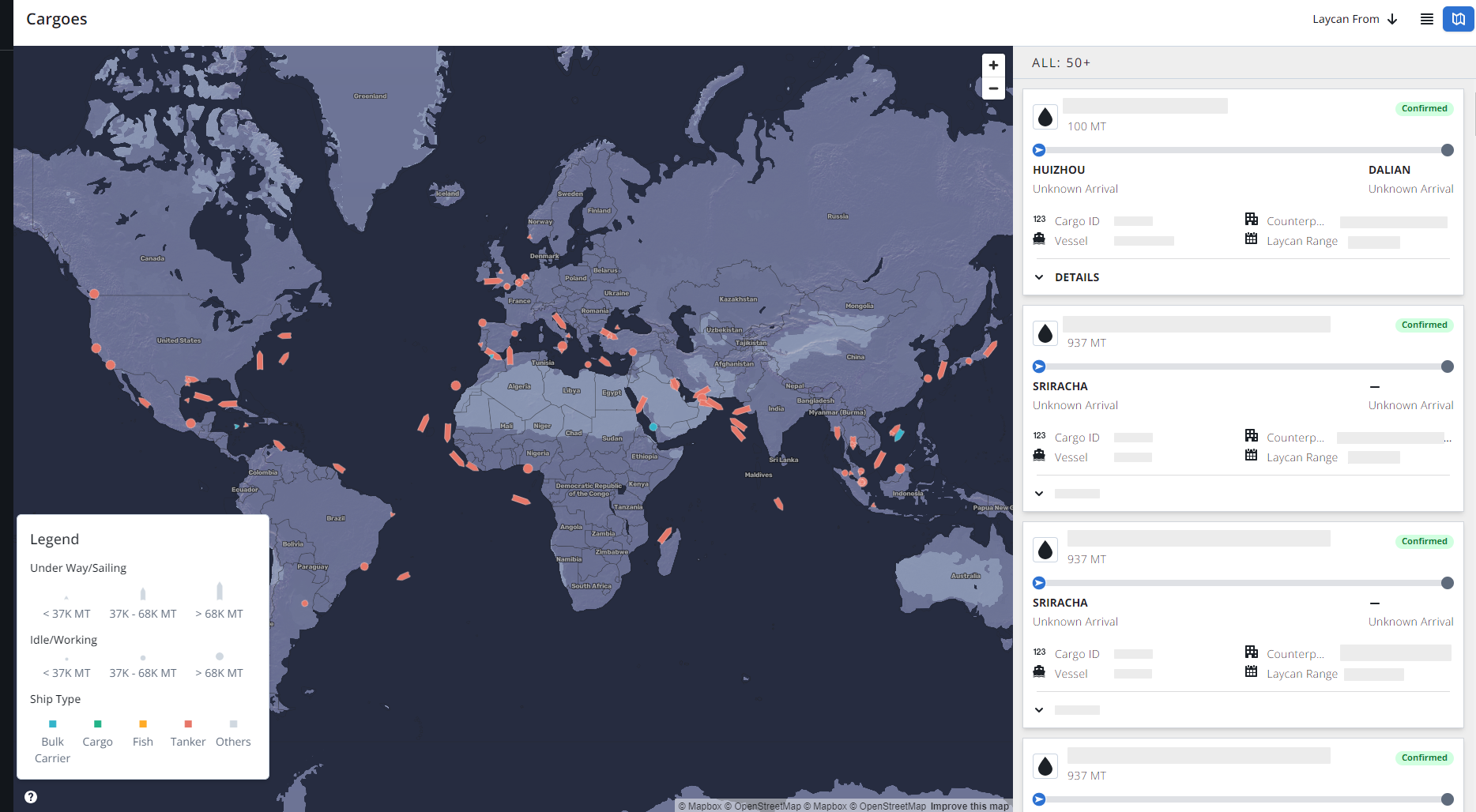
The IMOS X map leverages AIS, Oceanbolt, and IMOS Voyages. The following table shows the specific data sources for each field in the Cargo Map.
Map view
|
Field Name |
UI element |
Oceanbolt AIS |
IMOS |
External |
|
|---|---|---|---|---|---|
|
1 |
Vessel Position |
Map |
✓ |
|
|
|
2 |
Vessel IMO |
Vessel Hover |
✓ |
|
|
|
3 |
Cargo Name |
Cargo Card |
✓ |
|
|
|
4 |
Vessel Type |
Map(see Icon Key) |
✓ |
|
|
|
5 |
DWT |
Vessel Hover |
✓ |
|
|
|
6 |
Year build |
Vessel Hover |
✓ |
|
|
|
7 |
Status |
Vessel Hover |
✓ |
|
|
|
8 |
Direction |
Vessel Hover |
✓ |
|
|
|
9 |
Destination |
Vessel Hover |
✓ |
|
|
|
10 |
Last Updated |
Vessel Hover |
✓ |
|
|
|
11 |
Next Port ETA |
Vessel hover |
✓ |
|
|
|
12 |
IMOS (Cargo Card) |
|
✓ |
|
|
|
13 |
Speed |
Vessel Hover |
✓ |
|
|
|
14 |
Vessel Image |
Vessel Hover |
|
|
Ship Spotting (https://www.shipspotting.com/) |
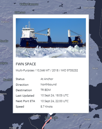
Vessel Details card
|
Field Name |
UI element |
Oceanbolt AIS |
IMOS |
External |
|
|---|---|---|---|---|---|
|
1 |
Vessel Position |
|
✓ |
|
|
|
2 |
Vessel IMO |
|
✓ |
|
|
|
3 |
Name |
|
✓ |
|
|
|
4 |
Vessel Type |
|
✓ |
|
|
|
5 |
DWT |
|
✓ |
|
|
|
6 |
Year build |
|
✓ |
|
|
|
7 |
Status |
|
✓ |
|
|
|
8 |
Direction |
|
✓ |
|
|
|
9 |
Destination |
|
✓ |
|
|
|
10 |
Last Updated |
|
✓ |
|
|
|
11 |
Next Port ETA |
Vessel hover |
✓ |
|
|
|
12 |
IMOS (Cargo Card) |
|
✓ |
|
|
|
13 |
Speed |
|
✓ |
|
|
|
14 |
Vessel Image |
|
|
|
Ship Spotting (https://www.shipspotting.com/) |
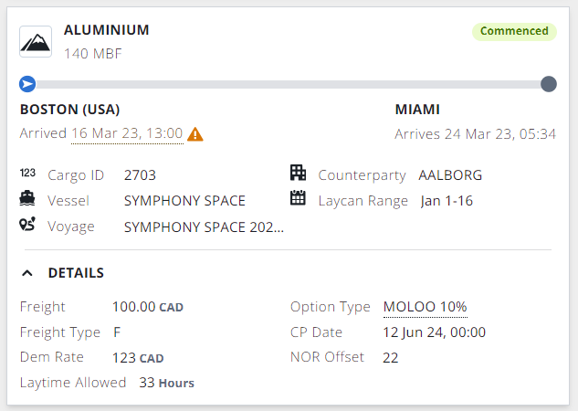
Cargo cards
|
Field Name |
UI element |
Oceanbolt AIS |
IMOS |
External |
|
|---|---|---|---|---|---|
|
1 |
Cargo Name |
IMOS Cargo Card |
|
✓ |
|
|
2 |
Status |
IMOS Cargo Card |
|
✓ |
|
|
3 |
Cargo Qty |
IMOS Cargo Card |
|
✓ |
|
|
4 |
Load Port |
IMOS Cargo Card |
|
✓ |
|
|
5 |
Discharge Port |
IMOS Cargo Card |
|
✓ |
|
|
6 |
Laycan Start |
IMOS Cargo Card |
|
✓ |
|
|
7 |
Laycan End |
IMOS Cargo Card |
|
✓ |
|
|
8 |
Cargo ID |
IMOS Cargo Card |
|
✓ |
|
|
9 |
Counterparty |
IMOS Cargo Card |
|
✓ |
|
|
10 |
Freight Rate |
IMOS Cargo Card |
|
✓ |
|
|
11 |
Freight Type |
IMOS Cargo Card |
|
✓ |
|
|
12 |
Demurrage Rate |
IMOS Cargo Card |
|
✓ |
|
|
13 |
Laytime Allowed |
IMOS Cargo Card |
|
✓ |
|
|
14 |
Option Type |
IMOS Cargo Card |
|
✓ |
|
|
15 |
CP Date |
IMOS Cargo Card |
|
✓ |
|
|
16 |
NOR Offset |
IMOS Cargo Card |
|
✓ |
|
|
17 |
Laycan Alert |
IMOS Cargo Card |
✓ |
|
|
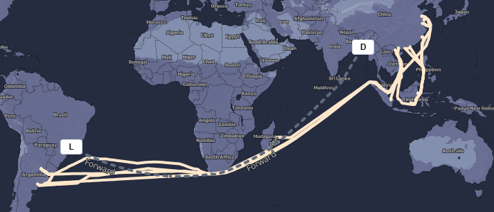
Routing
|
Field Name |
UI element (Map) |
Oceanbolt AIS |
IMOS |
External |
|
|---|---|---|---|---|---|
|
1 |
IMOS voyage routing line |
Blue line, labeled sailed |
|
✓ |
|
|
2 |
Forward routing line |
Dashed grey line, labeled forward |
|
✓ |
|
|
3 |
Port function Icon |
White box with a letter |
|
✓ |
|
|
4 |
AIS routing line |
Yellow line |
✓ |
|
|
|
5 |
Vessel Icon |
Key on the map for icons, current position |
✓ |
|
|
|
6 |
Port function hover |
Displayed when hovering over the port icon |
|
✓ |
|
|
7 |
Vessel Details Hover |
Displayed when hovering over the position |
|
✓ |
|
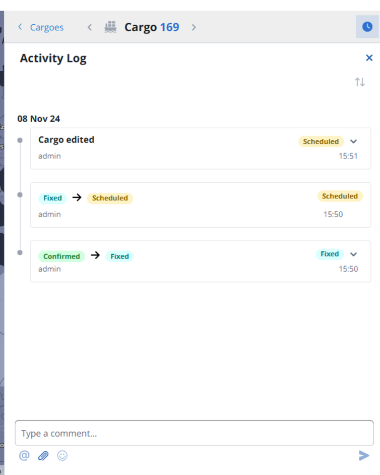
Activity Log
|
Field Name |
UI element |
Oceanbolt AIS |
IMOS |
External |
|
|---|---|---|---|---|---|
|
1 |
Object Edited |
Activity Log panel |
|
✓ |
|
|
2 |
Status |
Activity Log panel |
|
✓ |
|
|
3 |
Attachment |
Activity Log panel |
|
✓ |
|
|
4 |
Comment |
Activity Log panel |
|
✓ |
|